In a recent posting by W2IK, the upcoming drill on Saturday, August 29th, was discussed in rather general terms. Since that time, we’ve increased the scope of this event somewhat. We’ve added one ARES group (Hayes / Caldwell County) to the mix, and have room for more if other groups want to participate.
The event will only last 3 hours of radio time (11am – 2pm Saturday), compressing several days into 3 hours. What fun! We’ll be using local VHF freqs for operations near SA and another freq for local CC comm, plus a 40 meters net for the group, and MARS’s HF freq for their internal operations. We’ll be using the NWS office in New Braunfels KD5UMW and Drisocoll Childrens Hospital W5DCH as net controls.
Event: Hurricane “Albert” is expected to make landfall just north of Corpus with maximum winds at 130 mph.
- Hour 1 – Pre-Landfall – evacuation of residents in coastal cities in path of storm. Problems with evac routes and major side routes. Status of Shelter fill rates, etc.
- Hour 2 – Landfall – Loss of power, high winds, property damage noticed, major flooding and high surf conditions. Problems with evac routes and major side routes. Status of Shelter fill rates, etc.
- Hour 3 – Post-Landfall – Sending in teams to evaluate damage, return residents, status of evac routes being returned to normal use, power failures in area, comm failures in area due to towers blown or power failures, etc. Wrap up.
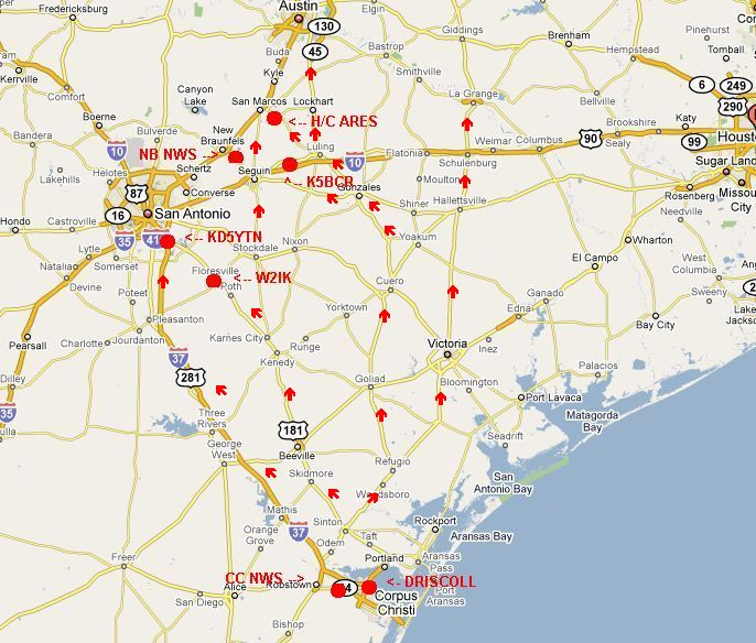
We’ll be “activating” stations physically at these locations:
- The National Weather Service Office in New Braunfels
- The National Weather Service Office in Corpus Christi
- The Driscoll Children’s Hospital in Corpus Christi
- The Hayes / Caldwell County ARES group up in San Marcos,
- The Hill Country REACT Team at the Seguin Rest Area on IH-10, MM619 WB
- The Bexar Operators Group near the IH-37 and Hwy 181 exchange
- The Navy – Marine Corps MARS units in Floresville and elsewhere along IH-37, such as Three Rivers, George West, etc.
Example below: map of area showing likely flow of traffic evacuation from target area. Not official map used by TX DEM, etc., just something tossed quickly together to illustrate why these physical locations were chosen.

Should be a fun event, as long as all those folks who willbe outdoors, remember to apply their sunscreen, wear those hats, and keep hydrated at all times. The folks operating indoors need to just make sure they… well I’m sure they’ll figure it out…
