An Update on the New Course
By Milton Johnson, N5HMJ
This is just a short communication to let you know what has been happening over the last month with the 2009 BikeMS: Valero Alamo Ride to the River!
RIDE TO THE RIVER HAMS WEB SITE
First I have created a new web site for the Amateur Radio community supporting the Ride to the River. It is called “2009 BikeMS: Valero Alamo Ride to the River HAMS” and is located at “www.n5hmj.com/BikeMS”. Why a new site? What happens with the YAHOO group? Well with the change in the ride’s name and course change, a group called “Bike to the Beach HAMS” was no longer appropriate. The second reason was that I could not succeed in getting even 50% of the Amateur Radio operator volunteers to join the group, so I decided not to fight it and created the new site. I will eventually disband the YAHOO group.
At the Ride to the River HAMS, you will find the latest information such as:
• The periodic communications I send out
• Information on the new Amateur Radio Team Structure
• How to volunteer
• Volunteer position descriptions and requirements
• SAG guide
• Links to the current official course map
• Other information as I continue building the site.
CURRENT STATE OF THE COURSE
As is to be anticipated, the course is in a minor state of flux. The goals for the course are: 75 mile minimum on Day 1 with a 25 mile optional “Century” extension; Day 2 will be about 60-65 miles. Yes, as you may have noted, the ride is not billed as 150 miles. I have toured the current course twice and have the following observations.
First the breakpoints are generally larger with two exceptions. On Day 1, there is the “Olmos Breakpoint” on Hwy 467 as it goes by “Downtown Olmos”. It is located where Olmos Loop leaves 467 and loops north through “Downtown Olmos”, when you see it you will understand the quotes around “Downtown Olmos”. The Google GPS coordinates are 29.4405,-98.037695.
On Day 2 we have the “Mesquite Pass Breakpoint” located on Hwy 46 at the Google GPS Coordinates 29.470276,-98.015427. This is the one problem child I am presently aware of. It is a two lane road without any real parking space. The saving graces are the riders should be strung out so hopefully all the riders will not be arriving at the same time, and it is marked by a large municipal type water tower that is visible for miles.
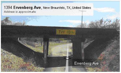
Next observation, on Day 1 the Century extension will use River Road in New Braunfels. The riders will go under a railroad trestle bridge with a seven foot 10 inch clearance!! The trestle is actually located on Ervenberg Avenue (Google GPS coordinates 29.741843,-98.11129) which the riders use to go from River Road to Breakpoint 5 on Gruene Road. Yes, SAGs will have an alternate route available to avoid the trestle, but I’m willing to buy a beer to the first HAM that loses their antenna(s) to the trestle on Day 1. I’ll take your picture by the trestle with the broken antenna(s) and you win the beer.

COMMUNICATIONS AND APRS
Communications on the new course is a big item. Shane (NS5D) is heading the team assessing the repeaters that will be used to cover the route. While it appears that one repeater will not cover the entire route, we may have linked repeater systems that will eliminate the need for two separate nets. This like everything else is a work in progress.
APRS coverage should be much better, so if you want to make sure your APRS system is working that’s a good thing. Barry (W5BLH) is leading the APRS efforts. I’ll be running APRS on my SAG.
MISCELLANEOUS COMMENTS
Tony Ralf is now KE5ZTZ! Yes he passed his exam at the one day crash course. I wonder who will get KE5ZZZ? As another note in a conversation with Tony I asked how Corpus Christi and Beeville reacted to the change in the course. Tony said Corpus Christi understood and wished us luck, but the interesting item was when he spoke with the president of Costal Bend College in Beeville. The president told Tony that actually this was good news for the college. After the 2008 ride, the college had decided that the event had grown too large for the college and that the MS Society would have to find another location for the overnight. It seems a major change was in the cards for 2009 even if the route had not changed.
Well that’s it for now, I’ll let you know more as I know it. If you have any questions or want to volunteer visit Ride to the River HAMS at “www.n5hmj.com/BikeMS” or email me at “Milton@n5hmj.com”. See you on the ride!
Milton Johnson – N5HMJ

March 22nd, 2009 at 4:12 PM
AS STATED BY N5HMJ:
” Your duty is to provide simultaneous VHF & UHF communications to Net Control and SAG vehicles approaching your breakpoint.
o Net Control Communications: A mobile VHF radio transmitting ~50 watts is required. As this is the first year for this course I suggest that you have the ability to place an antenna atop a 12 foot mast. You will be communicating via a VHF Repeater.”
If you wish to build a vhf/uhf antenna which would be perfect for this type of service, see:
http://www.armymars.net/w2ik/w2ik%20archive/hometown.aol.com/alonestaryank/selfj.html
or
http://www.armymars.net/w2ik/w2ik%20archive/hometown.aol.com/alonestaryank/VHFDeploy.html
I have in my stock of antennas about 8 of these types which I would be willing to loan out. If you are interested, email me two weeks before the event at: alonestaryank@aol.com
Bob